The Version of Record of this Author's Manuscript has been published and is available in Landscape History 2019 (40.1, pp 59-70) http://www.tandfonline.com DOI: 10.1080/01433768.2019.1600944
Introduction
This paper presents evidence, often still observable in the field, of
a coherent and managed network of roads and tracks within the orbit of medieval
monasteries and their estates; a component of a wider PhD research project assessing
the impact of the medieval monastery on the historic landscape. A hypothesis
that the topographical legacy of the monastery has remained a central element
(though often hidden or unseen) of the genius
loci of a study area in the southern Welsh Marches has been explored,
examining how this has influenced the development, experience and remembrance
of these landscapes up to the present day.
Fig. 1: Distribution of monastic houses in the southern Welsh Marches study area (Source: map drawn by the author in ArcGIS® using Ordnance Survey 1:25,000 Scale Colour Raster, 2016 and 1:5000 Historic Counties data layers, downloaded from Digimap® under licence, http://digimap.edina.ac.uk/, and Historic Counties Trust http://county-borders.co.uk/).
The area under examination here encompasses Herefordshire south of the
River Wye, the Forest of Dean district of Gloucestershire and most of the
historic county of Monmouthshire. This region, spanning the Anglo-Welsh border,
contains a mixture of pays, of both
upland and lowland, and champion and bocage
landscape character and was also heavily colonized by several religious orders
during the Middle Ages, as can be seen in the distribution map at Fig. 1. Within this regional geography, the Cistercian abbeys of Llantarnam and
Tintern and Augustinian Llanthony Priory provide the case study landscapes for
the project.
Three routeways in
particular – one from each house – are described. Each has been walked by the
author as part of a wider traversing of the case study terrains, deploying, in
synthesis, field methods from both landscape archaeology and cultural geography
- still an underutilised modus operandi in
the context of historic landscape study. Such exploration on foot is partly
inspired by Andrew Fleming’s (2009, 2010) walking and horse-back journeying on
the Monks’ Trod long-distance road linking Strata Florida Abbey with its
granges across the uplands of mid-Wales.
The problem with medieval roads
The popular view of medieval roads
is that they were much like medieval life: nasty, brutish and short. Such
route-ways were poorly
maintained, difficult to progress along and largely restricted to relatively
parochial journeying. This
narrative suggests long centuries of struggling through the muddy, rutted
remains of the Roman road system, waterways the preferred
option for long-distance travel or bulk transport (Oram 2016, p. 303). Medieval
ways, in this view, were generally not carefully planned or engineered; rather, they were more spontaneous developments, as popular
routes from A to B ‘made and maintained themselves’ through use (Wright 1985,
p.42). As Paul Hindle (2002, p. 6) has pointed out,
‘essentially the road was not a physical entity, a thin strip of land with
definite boundaries; rather it was a right of way, an ‘easement’, with both
legal and customary status’. Though constant use would often
lead to a physical track developing, in many places its actual course,
unconstrained by fence, hedge or wall, may not have been stable over time (Morriss
2005, p. 13). Outside of the shrinking open commons, in country where
the landscape was being plotted and pieced into an increasingly enclosed
tapestry of field, arable strip and coppice, many of these roadways would
become narrow and sunken, surviving into modern times as the holloway ‘ghosts’
of medieval travel and transport (Muir 2004, p. 170); ‘landmarks that speak of
habit rather than of suddenness … the result of repeated human actions’
(Macfarlane et al 2012, p. 3).
Tracing the origin and line of the roads and trackways of the Middle
Ages is often a difficult task. Whilst documentary evidence for medieval ways
is fragmentary and incidental, the physical trace can be more substantial. Old
tracks are, however, an elusive artefact, now often hard to recognise on the
ground: sometimes manifest archaeologically as little-altered holloways,
narrow terraces or other earthwork remains, otherwise more ‘transient drift ways’
linking farm and field only visible from aerial photography or satellite
imagery, or even obliterated or much altered by subsequent generations of
wayfarers and later changes in transport infrastructure, agricultural practice,
enclosure and encroaching vegetation (Colyer 1984, p. 12; Hindle 2002, p6; Taylor
1979, pp.117, 119). As it is often difficult to date old trackways
based on field evidence alone, documentary confirmation of medieval use (often
sparse), name evidence or dated associated archaeology is needed to provide
certainty, constraining the study of this important component of the medieval
landscape. As a consequence, relatively little has been written about ‘where
the roads were’ or identifying examples of integrated networks (Hindle 2002,
p. 5). To some extent, the literature that has appeared on this subject has
tended to buttress the ‘nasty and brutish’ interpretation.
Christopher Taylor’s (1979, p. 150) view, conveying almost Pythonesque
medievalism, seems still to predominate: ‘any movement along medieval roads was
uncomfortable at best and unbelievably difficult at worst’; but were things always
this bad? An assumption of unmade and arduous ways as the medieval norm may
partly be due to the aforementioned lack of study and fieldwork, limited documentary
evidence and the overlay of modern roads in more recent times (Morriss 2005, p.
114). Yet communities and organisations such as the monastic orders had a
motivation to maintain roads out of economic self-interest and
to bolster their symbolic function as boundary features, keeping tracks in
reasonable order and clear of obstruction for their day-to-day use, as will now
be explored (Morriss 2005, pp. 37-8; Oram 2016, p. 306).
Following monastic routes
This paper presents examples from monastic estates to suggest that
medieval abbeys and priories, powerful corporations of their time, were forging
and improving communication networks across their landed possessions in a
sustained and systematic way. Monastic houses would have
required a network of paths and lanes for the regular movement of stock,
produce, people and goods to and from geographically spread estates, farms and
satellites, provincial markets, neighbouring monastic and secular nodes
and so forth. They were also a focus for the regular movement of monks,
ecclesiastical officials and high-status dignitaries, traders and other
visitors and travellers who would need to follow such routes. Pilgrims, the
poor seeking charity and other more workaday movement would have added to the
ebb and flow. All the while, monasteries were engaged in expansive agricultural
and industrial production to meet the needs of the conventual community, as
well as trading surplus produce with the wider world (notably the export of
wool). A serviceable communications network to facilitate both parochial and longer
distance business and trade was essential. Social, economic, ecclesiastical and
political activities were therefore a key driver in the development and usage of
route-ways by monasteries throughout the countryside (Rackham 1986, p. 270).
As Richard Muir (2001, p. 58) has pointed out in relation to Cistercian
establishments in the north of England:
‘The
members of the great Cistercian houses, and particularly the lay brethren who
served them, needed to be on the move. Their granges spanned areas very much
larger than most farms, whilst their far-flung estates involved them in
considerable travel.’
The monastery was at the heart of a web of highways and byways. ‘Way-leave’,
the right of passage, was an essential aspect of the monastic economy (Williams
2001, p. 249). For instance, many of Tintern Abbey’s charters guaranteed
explicit rights of ‘a free road’, access and passage ‘free from toll’ or any
other hindrance throughout the donor’s lands (Heath 1806, unpaginated; PRO
1908, p. 105). This not only made a geographically dispersed network of
granges and manors feasible, but also enabled the abbey, its estates and the
wider world to be physically linked by a system of travel-ways radiating out
from the convent. Communication was also a factor in the strategic acquisition
and consolidation of monastic estates, with holdings strung along routes to
markets, coastal ports and quays (Bezant 2013, p. 137; Hindle 1998, p. 44).
For example, Tintern’s Modesgate grange became a staging post on the way to and
from the abbey’s Gloucestershire lands. Reached from the Abbey Passage ferry
across the Wye, Modesgate was a nodal point for land routes fanning out to the
abbey’s granges and further east into England. From the slipway, a
well-preserved rise of pitched stone and banked path testifies to both the
heavy traffic using this route and the sophistication of its construction (Fig.
2). This track then splits, the left-hand branch a broad, cobbled pathway to
Brockweir grange known as the Monks’ Path; the right-hand way, Abbey Road, climbing
to Modesgate via the Abbey Gate through an early-medieval
earthwork associated with Offa’s Dyke (Baggs & Jurica 1996, p. 151; Morgan & Smith 1972a,
p. 58; 1972b, p. 106; Thomas
1839, p. 41).1

Fig. 2: Stone-pitched track climbing from the Abbey Passage ferry at Tintern (Source: author).
Much of the monastic-era road network would have continued in use after
the Dissolution, whether by the local populace or for longer-distance travel,
for instance as part of drovers’ ways. Shorn of the monastic rationale
for movement, however, other old tracks fell out of favour or,
whilst still used for parochial traffic, declined in use and repair (Fleming
2009, pp. 83-5). There is some evidence of a significant
deterioration in the general state of the road system by the end of the
sixteenth century, perhaps partly explained by the fall of the monasteries
which had been responsible for much of the road maintenance that had taken place; also, no doubt, due to a rapid general
growth in trade and economic prosperity putting additional pressure on the
network (Hindle 2002, p. 17; Morriss 2005, p. 40). During a
parliamentary enquiry prior to the counties’ Turnpike Act in the mid-eighteenth
century, Colonel Valentine Morris, owner of Piercefield Park south of Tintern,
replied to the questions ‘what roads are there in Monmouthshire?’ with ‘None’,
and ‘How then do you travel?’ with ‘In ditches’ (Taylor 1861, p. 32). The
nineteenth century saw a shift, accelerated during road modernisation in the
mid-twentieth century, in which previously important routes, their usage often
stretching back to the Middle Ages, became marginal and eventually fell out of
regular use and repair. Such ‘roads’ have in some cases been revived as walking
paths or bridleways or have quietly sunk back into the landscape.
Traversing the hills to Llanthony Priory
So, to the first case study example. From historic and modern
cartography, a thick spread of trackways can be traced radiating out from Llanthony
Priory, deep in the Vale of Ewyas in the Black Mountains, and
connecting it with its manorial hinterland of Hothneyslade and the wider
communication network. The landscape inherited by the priory would have
included pre-existing – often prehistoric – tracks up to and along the mountain
watersheds, either from transhumance practice or long-standing trade routes,
often remaining in medieval use: the path traversing the western heights of the
valley was still known as the ‘great ridge road’ in the late-sixteenth century (Colyer
1984, p. 10).2 As the priory’s manorial estate evolved
throughout Hothneyslade, lower-level lanes developed binding farmsteads,
churches and hamlets more permanently.
In the nineteenth century, the Reverend Roberts (1846, p. 218) noted
that medieval sources regularly mentioned the high route over the Hatterall
ridge as ‘the ordinary way to Llanthony.’ Before alternative low-level valley
routes to the south were instigated, this was the main way for most visitors
and traffic from the lordship stronghold at Longtown and the priory’s many estates
in Herefordshire and England more widely. The track now most used to reach the
priory ruins from the ridgeway (part of the Offa’s Dyke Long Distance Trail) is
commonly called ‘the Beer Path’. Received wisdom, as oft repeated in guide
books and other literary references, is that this name derives from the Welsh
Rhiw Arw, originally cwrw meaning
‘ale’, a memory of the use of the path by the canons of Llanthony to transport ale
(Hurley 2010, p. 91; Sinclair 2001, p. 313; Watkins 2005, p. 51). This,
though, is a cautionary tale of the risk of misinterpreting names in the
landscape. Rhiw Cwrw (‘ale pass’) is, in fact, an ancient naming of the saddle
over which the way from Longtown, bastion of the de Lacy Marcher Lords and
benefactors of the priory, climbs from the other side of the Hatterall ridge. Rhiw
Cwrw was first recorded in the eighth century, in the Book of Llandaff, and so the name pre-dates the priory by at least
several centuries (Coplestone-Crow 1989, p. 56; Wedell 2008, unpaginated). The Beer Path descending to the priory seems latterly to
have taken on an Anglicised version of this old name, so giving rise to the
story of monks carrying ale along this trail (Hando 1944, p. 91). That its
line reaches the priory enclosure via a nondescript field path crossing its
northern boundary rather than arriving at the gatehouse to the south is also
problematic if it is to be considered monastic. A more likely origin is as a rhiw or drift road used by farmers to
move stock up and down from the common upland grazing.

Fig. 3: Route of the Old Roadway to Llanthony Priory annotated by the author on a vertical aerial photograph (Source: © Crown copywrite, Royal Commission on the Ancient and Historic Monuments of Wales, 1975, DI2007_1170 75.039-014).
Fieldwork for this project has identified a now-disused track (prominent in the aerial photograph at Fig. 3) charting a
gentler course down slope of and parallel with the Beer Path as the likely main
medieval approach to the priory from the Hatterall ridgeways. Its lower portion,
Old Roadway on the tithe map, is now in part a deeply-incised and overgrown sunken
way: one of ‘the deep holloways that seam the landscape’ in Robert
Macfarlane’s (Macfarlane et al 2012,
p. 4) words, arcing into the approach lane to the priory, elsewhere a broad
drove-way now cut by watered gulleys.3 As it climbs the hillside, the
track crosses a stream at which the remains of a rudimentary stone bridge,
medieval in form, can be observed (Andrew Fleming pers. comment). It then rises
to run with and cross the post-medieval ‘parish road’ travelling along the
eastern flank of the valley before ascending the upper heights of the hillside
to switchback and meet the way to Longtown at a crossroads with the ridgeway on
the Rhiw Cwrw col.
Here the track also runs close to the ruined farmstead of Footway before
climbing more steeply to the ridge, the name a memory of the passing routeway,
literally the ‘foot of the way’ or perhaps derived from ffordd meaning ‘road’. A 1679 manorial court entry records that ‘we find that the way
leading from Lanthony to Footway … find it only a bridleway’:
an indication of the diminished status and poor state of this previously
important monastic circuit, perhaps now only used as a farmer’s rhiw to the high pasture.4 The centre of gravity had
by then long shifted from movement between the priory and the old Longtown seat
of the de Lacys to Llanvihangel Crucorney to the south, home of the Arnold
family, secular lords of Llanthony’s local estates after the priory’s demise.
William of Wycombe’s5 12th century Mirror of the Life of prior Robert de
Béthune provides a visceral
recounting of the prior’s journey by night over the Hatterall ridge from Longtown,
via this track:
‘When he arrived at the
foot of the mountain they call Hattarell night had already shut in the day … He
ascends slowly, sounding the road with his staff … And now at last he attains
the summit of the mountain, where the upright shaft of a cross offers a place
of rest … Rising from his resting place, he attempts the descent of the
mountain, which he finds to be even more severe than the ascent … The benighted
guest knocks at the door of the porter’s lodge, is recognised, and admitted’ (Roberts
1846, pp. 214-5).
Further fieldwork has identified the earth-banks and stonework of an
engineered terrace-way descending to Llanthony from Bal-bach on the opposite side
of the valley down the steep gully of Cwm-bwchel. This track, lined with
significant segments of the relict stone slabs and revetment walling of its
construction, connected with both the ‘Great ridge road’ along the western
elevation of the valley and a route, Rhiw Pyscod (‘fish track’), over the Black
Mountains to Llangorse Lake in Brecknockshire on which the canons had fishing
rights; the track used to deliver live fish wrapped in wet rushes to the priory
fishponds (Procter 2012, p. 103; Roberts 1846, p. 233).
Some old ‘ways’ to Tintern Abbey
Now turning southwards down the lower Wye Valley to Tintern Abbey, at
the apex of a web of land and water communication (Fig. 4). Several land routes
radiated out south-westwards from the Great Gatehouse to the abbey’s
Monmouthshire estates, connecting with other recorded medieval ways. What is now a minor lane runs from the gate before dividing
into the Long Way path via Ruding grange and the Stony Way over the high
Porthcasseg plateau: these were alternative routes to the key demesne grange at Rogerstone, the
lordship hub of Chepstow and the abbey’s Severn-shore holdings.
Fig. 4: Medieval routeways around Tintern Abbey and its Wye Valley estates (Source: map drawn by the author in ArcGIS® using Ordnance Survey 1:10560 County Series 1st edition, Monmouthshire, 1887 and Gloucestershire, 1889 data layer, downloaded from Digimap® under licence, http://digimap.edina.ac.uk/).
‘The way leading from the abbey
… which is called Stony Way’, first recorded in 1451,
was a major cobbled lane, its surface still substantially in place in parts,
climbing a narrow valley southward towards Porthcasseg and presumed by Welsh
Cistercian historian David Williams (1976, p. 134) to be a ‘monastic
enterprise’ (Bond 2010, p. 294; Bradney 1993, p. 256) (Fig. 5). Before cutting
through a limestone cleft, the way commences as a track divided from a parallel
stream by a stone revetment, morphing into a deep-banked holloway running on to
the metalled lane passing Porthcasseg Farm and down to the medieval vill of St. Arvans. On a visit to
Tintern in 1795, the poets Robert Southey and Samuel Taylor Coleridge
experienced a floundering night-time return from a long day out, down the steep
and rocky Stony Way (Matheson undated, unpaginated). A decade later Charles
Heath (1806, unpaginated) walked the way, described as the ‘foot road from
Tintern to Chepstow’, now reduced to a narrow and rough byway through encroaching
woods.
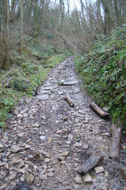
Fig. 5: The Stony Way, climbing away from Tintern Abbey (Source: author).
A level and more circuitous passage to St. Arvans was followed by the
Long Way, recorded in the mid-fifteenth
century, which tracked a course along a narrow shelf between the Wye and looming
limestone cliffs avoiding the steep climb up and
over the shoulder of Gaer Hill and a sharp descent to the abbey.6 This was a better prospect for heavier loads
or during inclement weather. Footways charted on a 1763 estate map form a
shadowy trace of the way.7 Its previously unrecorded course, following
Public Rights of Way and disused embanked terrace-ways through the woods of the
Wye Valley, has been retraced on the ground during this project. The early-nineteenth
century turnpike road through the valley which became the modern A466 was
cut through the precipitous Black Cliff and Wyndcliff, parallel with, and in
places overlying, the old monastic track. Prior to the coming of this ‘new
terrace’ road, the narrow and meandering Long Way had seemingly long ceased to
be used as a through way to Tintern.
From St. Arvans southwards past Rogerstone grange, these two tracks
joined to become the Lodeway running south-west to link with highways to
Tintern’s estates in the Caldicot Levels (Williams 1999, p. 27). There are
some hints of road maintenance: in 1440 Porthcasseg tenants were admonished and
fined for not repairing stretches of the Lodeway between St. Arvans, Rogerstone
and Itton which may have been paved (Williams 1990, p. 27; 1999, p. 27). Lodeway
intrigues as a toponym with various possible origins. Lode is a place-name element denoting several Severn ferry
crossings and may indicate the way taken to a
landing-point on the navigable estuary. Other possible derivations are from
the Old English lad denoting a
watercourse or drainage channel, perhaps signifying the route to the abbey’s
reclaimed and ditched holdings on the Levels, or lodes, a south-west English term for veins or strata of minerals (Gelling & Cole 2003, p. 82; Mills 1995, p. 214; Raistrick 1972, p. 21). W.H.
Thomas (1839, p. 14) mentions local ‘lodes’ of limestone in the nineteenth century and the naming could be for the
transport of lime or iron ore, for which there is some evidence of medieval mining
on the abbey’s estates.
Walking with pilgrims from Llantarnam Abbey
Finally, a walk with pilgrims from Llantarnam Abbey on the north-west
frontier of the Anglo-Norman Marcher lands in south-east Wales: a track given
the modern appellation of ‘Pilgrims’ Way’ was part of an important medieval
pilgrimage route to the shrine of the Virgin Mary and healing well at the
abbey’s Penrhys grange, 30 miles west above the Rhondda. Penrhys was popular in
the fourteenth and fifteenth century, becoming one of the most revered wells in
Wales and attracting pilgrims from ‘over sea and land’ (Hurlock 2013, pp. 122-3;
Ward 1914, p. 357).
The journey from Llantarnam was an arduous one across high country via St Derfel's chapel, high on the shoulder of Mynydd Maen,
to reach the shrine atop a ridge known as Craig Rhiw Mynach (‘rock of the
monks’ road’). Madeleine Gray (1997, pp. 10-11, 26) has
retraced its likely line – in part probably prefigured by well-established old
ways contouring the hillsides to avoid the more difficult terrain of the valley
floor or exposed ridge-tops – based on contemporary descriptions, local
tradition, the position of wayside chapels and paths and roads in the modern
historic landscape. Llantarnam was a gathering point, providing a guesthouse,
advice and provisions for those setting out for Penrhys (Gray 1997, p. 11). From the gatehouse, the route passed along the old abbey
approach from Llanfihangel Llantarnam village, its meandering line then traceable
on the ground through the modern Cwmbrân townscape and up to Llanderfel.

Fig. 6: Quartz conglomerate
blocks lining Hollow Lane up to Llanderfel, part of the pilgrims’ way from
Llantarnam Abbey (Source: author).
Passing the long-gone Scybor Cwrt grange along what is now the modern
Llantarnam Road, pilgrims climbed a low rise to the purported wayside chapel at
St. Dial’s along a still-extant lane (Gray 1997, p. 25). A disused holloway
with signs of cobbling below its surface, declining to a series of footpaths and
relict features through 1970s housing, now carries the walker along the manor
and parish boundary (Logan 2009, pp. 6-7). A further section of deeply sunken
way, Hollow Lane, then ascends the steepening slopes of Mynydd Maen before
sharply dog-legging south to follow another depressed lane to the old grange of Llanderfel and the ruins of St. Derfel’s
chapel. The pilgrims’ way ascends a further deep hollow above the chapel
site, known as the Slippery Way, and then follows a hillside shelf to progress
to the Ebbw valley and onward trails to Penrhys and the abbey’s more far-flung estates
and granges (Dovey and Waters 1956, p. 76; Gray 1997, p. 21). Hollow
Lane is lined with large quartz conglomerate boulders won from a band of
outcropping geology, known locally as ‘pudding stones’, which, it has been
suggested, may have been waymarkers for pilgrims (Burchell 2011, pp. 4, 33; Middleton
2011, p. 3) (Fig. 6). It is notable that such stones have been used for
walling and revetments alongside many other local tracks, as boundary stones,
in buildings and field walls, perhaps cause for scepticism that they were
specifically used to demarcate the pilgrim route.
Although
the post-suppression owner of Llantarnam and its estates, William
Morgan, a recusant Catholic, encouraged the continuation of pilgrimage to the
shrine after the Dissolution, the volume of wayfarers soon sharply declined (Hurlock
2013, pp. 123, 127). With improving low-level valley roads, mountain circuits
such as the Pilgrims’ Way over Mynydd Maen transitioned into byways for stock
movement and other local flows. The physical footprint of the pilgrims’ route
from the abbey towards the mountain was further diminished by the urban
development of Cwmbrân new town, though it can still be
tracked through the townscape by the keen-eyed; for instance, in a disused hollow section
unconsciously retained in a corridor of open space between housing estates.
Discussion
and conclusion
In Francis
Pryor’s (2010, p. 280) words, ‘far from representing a retreat from the cares
of daily life, the monasteries of the Middle Ages were important catalysts of
change and regional development.’ It’s not hard to imagine that the
effort, resources and planning that went into building the monastery and
developing expansive agricultural holdings and trading networks would also be
channeled into the important routeways bonding the house with these estates and
the outside world to ensure safe and efficient ease of passage. The engineered
ways discussed here and many other examples in the case study areas, banked or
hollowed depending on the terrain and with much evidence of cobbled and stone
surfaces, testify to this truism. As with Andrew Fleming’s (2009, 2010) findings
on studying the Monks Trod and other Strata Florida routes, the evidence
suggests an often-underestimated level of sophistication and investment in
medieval road construction and maintenance. The monastery, at least in its more
stable periods, providing institutional continuity, revenue, know-how and
labour. Sustained and heavy use of these
roads and paths during the longue durée
of the monastic community and economy, even where pre-existing ways were co-opted,
would have seen significant construction, improvement, wear and repair across
the network.
Spotlighting and recreating these trackways resets conventional patterns
of ‘fixed’ landscape features linked simply by lines on a map,
foregrounding considerations of movement and methods of communication (Reynolds
2009, pp. 420-423). Recognition of the multiple meanings of these shared ways
also dawns: to connect but also to mark and codify the landscape and people’s
interaction within it: ‘the integration of key topographical points – such as
boundaries, river crossings and crossroads – helped structure and give
spiritual context to the ordinary aspects of everyday life’ as people moved
about the landscape (Whyte 2009, p. 29). Travelling through, for
instance, the Abbey Gate on the way to the Wye ferry to Tintern representing
not just a waymark en route to the
abbey but also a passing from the open forest of Tidenham Chase into prescribed
monastic land. In the hills west of Llantarnam, the difficulty of the terrain
on the pilgrim way to the Penrhys shrine was leavened by wayside chapels such
as St. Derfels, but also an important component of the spiritual journey itself
(Gray 2011, p. 245). As such ways spread out from the monastery, they also
took on a geo-political role: linking economically and strategically important
places, acting as both ‘instruments of elite control’ for the
ecclesiastical and political class and safe space in sometimes bleak and
hostile landscapes (Altenberg
2001, p. 109; Fleming 2009, p. 83).
The monastic trods and trackways introduced here help to challenge
received wisdom that pre-modern roads were uniformly primitive, difficult and
very much non-permanent. Trade, high-status visitors, pilgrims and local
traffic became the multiple catalysts for a named and marked, maintained and
managed system of transit and safe passage. A transition from general
directions of travel into defined, maintained and named roads and footways can
be heralded as a key topographical legacy of the monastic era (Colyer 1984, p.
61; Moorhouse 1989, p. 59). Though many of these trackways enter the
documentary record in the post-medieval period, the network – like the roads of
the Roman times – was by then declining into a new ‘Dark Age’ of neglect and
forgetting, as after the Dissolution former monastic
estates reverted to out-of-the-way backwaters once more; still lining the landscape but no longer hubs of travel and
commerce, their busy, strategic, symbolic past falling out of memory. As the
poet Edward Thomas (2004, p. 96) would have it, ‘roads go
on, while we forget.’
Notes
1 1. Gloucestershire Archives, Tidenham (Wollaston and Lancaut)
Inclosure Map and Apportionment, 1815, Q/R1/144.
2 2. Harley Archive, Brampton Bryan, Herefordshire,
Cwmyoy Manor Court Baron, 1567-1754,
17/28/5.
3. National Library of Wales (NLW), Cwmyoy (Lower Divisions) Tithe Map and Apportionment
Schedule: Map 2 of the Parish of Cwmyoy in the County of Monmouth, 1852.
4 4. NLW, Cwmyoy Manor Court Book, 1665-1775, National Library
of Wales, 1184.
5 5. William
of Wycombe was chaplain to Prior Robert in 1127, rising to become the fourth
prior of Llanthony himself from 1137-47.
6 6. NLW, Porthcasseg Manor Court Book, 1262-1714 (incomplete),
Badminton Papers Vol III Monmouthshire, p34-59, 1657.
7 7. NLW, A Plan of the Estates of His Grace the Duke of Beaufort in the
Manor of Portcassegg, 1763, Badminton Vol. 2 143/1/1.
Bibliography
Altenberg, K., 2001. Experiencing landscapes. A study
of space and identity in three marginal areas of medieval Britain and
Scandinavia. Thesis (PhD). University of Reading.
Baggs, A. & Jurica, A., 1996. Hewelsfield
and Brockweir. In: C. Herbert & N. Currie, ed. A history of the county of Gloucester: Bledisloe Hundred, St.
Briavels Hundred, the Forest of Dean,
Victoria County History, Vol. 5. London: Boydell and Brewer, pp. 150-9.
Bezant,
J., 2013. Travel and communication. In:
J. Burton & K. Stöber, ed. Monastic Wales: new approaches. Cardiff:
University of Wales, pp. 133-45.
Bond, J., 2010. Monastic landscapes.
Stroud: History Press.
Bradney, J., 1993. A
history of Monmouthshire: vol. III part ii - the Hundred of Usk. London:
Merton Priory Press.
Burchell, R., 2011. The Ancient Cwmbrân Society Greenmeadow
Woods community archaeology project 2011 [online]. Cwmbrân, Ancient Cwmbrân
Society. Available from: http://docs.wixstatic.com/ugd/90e7f0_0a6c6d13c296456da86994c9c5e61217.pdf
[Accessed 25 October 2017].
Coplestone-Crow, B., 1989. Herefordshire place-names,
Monograph (BAR Series 214). British Archaeological Reports.
Colyer, R., 1984. Roads and trackways of Wales. Ashbourne:
Moorland.
Dovey, F. & Waters, H., 1956. A history of Llantarnam. Unpublished
manuscript.
Fleming, A., 2009.
The making of a medieval road: the Monks’ Trod routeway, mid Wales. Landscapes, 10 (1), pp. 77-100.
Fleming, A., 2010. Horses, elites …
and long-distance roads. Landscapes,
11(2), pp. 1-20.
Gelling, M. & Cole, A., 2003. The
landscape of place-names. Stamford: Shaun Tyas.
Gray, M., 1997. Penrhys: the archaeology of a pilgrimage. Morgannwg,
40, pp. 10-32.
Gray, M., 2011. Sacred
space and the natural world: the holy well and shrine of the Virgin Mary at
Penrhys. European
Review of History, 18, pp. 243-260.
Hando, F., 1944. The pleasant land of Gwent. Newport: RH
Johns.
Hindle, P., 1998. Roads and tracks of the Lake District.
Milnthorpe: Cicerone.
Hindle, P., 2002. Medieval roads and tracks. Princes
Risborough: Shire.
Hurley, H., 2010. The green lanes of Herefordshire. Ross
on Wye: Fineleaf.
Hurlock, K., 2013.
Pilgrimage. In: J. Burton & K.
Stöber, ed. Monastic Wales: new approaches. Cardiff: University of Wales,
pp. 119-31.
Logan, W,. 2009. Ancient Cwmbrân & the Cistercians community archaeology project site one: the Cistercian way, Greenmeadow, Cwmbrân [online]. Border Archaeology
Report BA0917TCBCACP/01. Available from: http://docs.wixstatic.com/ugd/90e7f0_6abe7b4ab17e432b9434dbc1fc8597b3.pdf
[Accessed 25 October 2017].
Macfarlane, R., Donwood, S. & Richards, D., 2012. Holloway. London: Faber and Faber.
Matheson, C., undated.
Enchanting ruin: Tintern Abbey and romantic
tourism in Wales [online]. M Library, University of Michigan. Available
from: http://www.lib.umich.edu/enchanting-ruin-tintern-abbey-romantic-tourism-wales/introduction.html
[accessed 6 March 2017].
Middleton, V., 2011. Conglomerates of Cwmbran their genesis and uses
[online]. Cwmbrân, Ancient Cwmbrân Society. Available from: http://docs.wixstatic.com/ugd/90e7f0_7d875851108f485685b703d0102451bb.pdf
[Accessed 25 October 2017].
Mills, A., 1995. A dictionary of English place names. Oxford:
Oxford University Press.
Moorhouse, S., 1989. Monastic estates: their
composition and development. In: R.
Gilchrist & H. Mytum, ed. The archaeology of rural monasteries. Oxford:
British Archaeological Reports, pp. 29-81.
Morgan, K. & Smith, B., 1972a. Tidenham including Lancaut. In: C. Elrington, N. Herbert & R. Pugh, ed. A history of the
county of Gloucester: Westbury and Whitstone Hundreds, Victoria County
History, Vol. 10. London: Boydell and Brewer, pp. 50-78.
Morgan, K.& Smith, B., 1972b. Woolaston. In: C.
Elrington, N. Herbert & R. Pugh, ed. A history of the county of
Gloucester: Westbury and Whitstone Hundreds, Victoria County History, Vol.
10. London: Boydell and Brewer, pp. 102-17.
Morriss, R., 2005.
Roads: archaeology and architecture.
Stroud: Tempus.
Muir, R., 2001. Landscape
detective: discovering a countryside. Macclesfield: Windgather Press.
Muir, R., 2004. Landscape encyclopedia: a reference guide to
the historic landscape. Macclesfield: Windgather Press.
Oram,
R, 2016. Trackless, impenetrable and underdeveloped? Roads, colonization
and environmental transformation in the Anglo-Scottish border zone, c. 1100 to
c. 1300. In: V. Allen & R. Evans,
ed. Roadworks: medieval Britain, medieval roads. Manchester: Manchester
University Press, pp. 303-325.
Procter, E., 2012. Llanthony
Priory in the Vale of Ewyas: the landscape impact of a medieval priory in the
Welsh Marches. Archaeology in Wales, 51,
pp. 93-106.
Pryor, F., 2010. The making of the British landscape: how we have transformed
the land from prehistory to today. London: Allen Lane.
Public
Records Office, 1908. Calendar of Charter
Rolls vol. III, 29 Edward I, 1-20 Edward II, 1300-1326. London: His Majesty’s
Stationary Office.
Rackham, O., 1986. The history of the countryside. London:
Pheonix.
Raistrick,
A., 1972. Industrial Archaeology: An Historical Survey London: Eyre
Methuen.
Reynolds, A., 2009. Meaningful landscapes: an early
medieval perspective. In: R. Gilchrist & A. Reynolds (ed.). Reflections: fifty
years of medieval archaeology 1957-2007. Leeds: Maney, pp. 409-434.
Roberts, G., 1846. Llanthony
Priory, Monmouthshire. Archaeologia
Cambrensis, iii, 201-245.
Sinclair,
I., 2001. Landor's tower. London:
Granta.
Taylor, C., 1979. Roads and tracks of Britain. London:
Dent.
Taylor, R., 1861. Taylor's illustrated guide to the banks of the
Wye, including Chepstow, Piercefield, Wyndcliff, the magnificent ruins of
Tintern Abbey, Monmouth, Ross, Raglan and Goodrich castles, and other parts of
the Welsh borders [online]. Hathi Trust. Available from: https://babel.hathitrust.org/cgi/pt?id=nnc1.1000417980;view=1up;seq=1
[Accessed 15 March 2017].
Thomas, E., 2004. Collected Poems. London: Faber and Faber.
Thomas, W., 1839. Tinterne
and its vicinity [online]. Hathi Trust. Available from:
[Accessed 21 February
2017].
Watkins, A., 2005. The old straight track. London: Abacus.
Ward, J., 1914. Our lady of Penrhys. Archaeologia
Cambrensis, XIV, pp. 357-406.
Whyte, N., 2009.
Inhabiting the Landscape: Place, Custom
and Memory, 1500-1800. Oxford: Windgather Press.
Williams, D., 1976. White monks in
Gwent and the borders. Pontypool: Griffin Press.
Williams, D., 1990. Atlas of Cistercian lands in Wales.
Cardiff: University of Wales Press.
Williams, D., 1999. Rogerstone grange,
St. Arvans. Monmouthshire Antiquary,
15, pp. 23-32.
Williams,
D., 2001. The Welsh Cistercians. Leominster: Gracewing.
Wright, G., 1985. Roads and trackways of the Yorkshire Dales.
Ashbourne: Moorland.