Friday 29 September 2017

PhD landscape walk - walking the ghost topography of Cwmbran new town


This is a description of one of a series of landscape walks through my PhD case study areas. Here the walk navigates a route around the post-war planned new town of Cwmbran in south-east Wales, developed over the former lands of Magna Porta, the 'home' manor of Llantarnam Abbey during the medieval period.

The walk commences at the church of St. Michael’s in Llantarnam village at the southern limits of the new town, taking in the cul-de-sac lane opposite running parallel with a silted-up ditch draining into a culvert under the main road. This ditch forms part of a system of leats which fed the now demolished corn mill in the village and likely date to the monastic period.

From here a long straight stretch of Llantarnam Road is followed, leading directly from the old lane to the abbey into the centre of Cwmbran. This road follows the line of the route between the abbey and its granges and manorial lands to the north and also forms the start of the pilgrimage way from Llantarnam to the shrine at Penrhys further to the west in the Rhondda valley. Now a main route into the town, this old road is utterly suburban, lined by ribbon development, a mix of some larger Victorian and Edwardian houses, unremarkable housing stock from this period and the mid-twentieth century, and modern day additions.


The mill leat opposite the church (Source: author).


Llantarnam Road looking north-west (Source: author).

Part-way along the road the memory of the abbey's Scybor Court grange (latterly Court Farm) rises. The school built on the site of the demolished farm during the development of the new town in the 1960s has now itself been replaced by a housing estate, ‘St. Michael’s Gate’ (this name a reference to the local church but perhaps a missed opportunity to remember the medieval grange). Further along the road, the grange is memorialised in the 1950s council housing of the ‘Court Farm Estate’, including Court Farm Close and Court Farm Road (is this association with social housing the rationale for the new estate utilising a different name?). Further progress along the road brings more nomenclature linking the area to the abbey: Llantarnam Dental Practice, Llantarnam Primary School, Court Road Industrial Estate etc.

The land farmed by the medieval grange here is uniformly flat, forming the broad flood-plain of the Afon Lwyd a few hundred metres to the east. The old flood meadows of the grange that have not been concreted over form one of the recreational areas created as part of the planned new town, now the site of a large boating and fishing lake and a golf course.


Court Farm Close, part of the 1950s estate built on the agricultural land of the monastic grange of Scybor Court (Source: author).

Passing the green space of Oakfield Park, sited on an area of woodland at a junction of old roads and populated by remnant oak and ash. Further greenery is observed at a roundabout marking the junction of the old road with one of the new access routes through the town. This is the marshy place bordering the lands of Scybor Court grange to the south and the abbey’s Gelli-las grange to the north: the industrial zone along the riverside here interspersed with more open green space and mature trees.
New town roundabout looking north with entrance to Court Road Industrial Estate to right (Source: author).

Across the roundabout a remnant field, crossed by the embankment of a disused railway line, also contains a hollow which may have been the line of the stream bounding the territory of the two granges.


Remnant field at boundary of Scybor Court and Gelli-las granges (Source: author).


Grange Road (Source: author).

The old track up to Gelli-las (still called Grange Road) is passed, now a residential street and service road for a supermarket and industrial units. Approaching the centre of Old Cwmbran, the small industrial settlement that preceded the new town and the housing stock becomes a mix of mid-nineteenth century cottages and late century worker’s terraces; the area now somewhat down at heal.

As the post-war trunk road into the centre of the town is bridged the old road curves westwards and climbs up the small hillock on which the medieval chapel of St. Dial’s, a stopping place on the pilgrimage route to Penrhys, stood. As the hill is climbed the character of the route changes, St. Dial’s Lane, bounded by an old wall and then hedge-lined, is now lined by fields: a rural snapshot amidst the urban new town. From a field containing a ruined barn, the site of Llanderfel pilgrimage chapel and the surrounding grange can be seen high on the side of Mynydd Maen looming in the distance to the west. This low river terrace hillock provides a prominent viewpoint and landmark in the landscape, probably explaining the location of the chapel here.


Section of old wall on lane up to St. Dial’s (Source: author).


The rural character of St. Dial’s Lane (Source: author).


Looking west towards the uplands of Mynydd Maen towards the site of Llanderfel chapel on the distant hillside (Source: author). 

The steepness of the northern slope of St. Dial’s descending to the adjacent town centre has preserved it from development. The jumble of post-war buildings forming central Cwmbran, complete with distressed concrete multi-story car park and landmark tower block, now overlie the grange farm of Gelli-las.


Central Cwmbran on the site of the Gelli-las grange (Source: author). 

A further stretch of ‘country lane’ hollows below tree-lined banks. Desire paths through an overgrown field are explored, bushes and trees now reclaiming the site of the long-demolished St. Dial’s House and most probably the medieval chapel. The approximate site of the old settlement along the lane is now unremarkably taken by a small Victorian terrace and a bungalow. As the lane strikes north alongside allotments, the open space to the south is the scene of a rising housing development, part of the Cwmbran neighbourhood which takes its name from the medieval chapel.


The site of St. Dial's House - and probably the medieval chapel - looking southwards (Source: author).

Descending from St. Dial’s, the lane runs alongside one of the modern roads through the new town to a roundabout. From here the line of the pilgrimage route continues westwards towards Llanderfel as a series of walking and cycle paths. This route will be picked up again later in the walk but now a diversion westwards through the remaining woodlands of the Freshwater suburb is followed. Here, remnant trees and dingles are intermixed with the housing of the new town, pathways running through the green spaces and linking residential areas with roads, schools and other infrastructure. The retention of significant woodland within the new town fabric is the result of a mix between idealism - the creation of the liveable, spacious neighbourhoods such as Fairwater and Greenmeadow with plenty of green areas – and pragmatism, with tree cover largely confined to the more difficult and marginal terrain alongside the courses of streams and steeper-sided gulleys.

  
St. Dial’s Lane beside the modern road through the western suburbs of Cwmbran (Source: author).


The route of the pilgrimage way picked up again via the footpath on the other side of the roundabout (Source: author).


Remnant woodland inter-mixed with new town housing in the Freshwater area of Cwmbran (Source: author).

In this elevated western part of the new town, open and green prospects are juxtaposed in places with some rather tired-looking housing stock. A public footpath followed through the block of woodland below Cwmbran High School comes to a dead-end at the school gates and meandering, sometimes litter-strewn, desire paths eventually lead to the old lane - Graig Road - still zig-zagging its nineteenth century course up through Fairwater, a hidden away but still extant artery for cyclists and dog-walkers masked by suburban closes. This route would have provided a more direct route up to the open common of Mynydd Maen from the abbey, by-passing the hilltop pilgrims diversion of St. Dial’s.


Housing in the Greenmeadow area of Cwmbran (Source: author).

Here rural tranquillity is found again as the lane crosses a stone bridge in a dingle carrying a fast-flowing stream down from the hillsides around Llanderfel. The arboreal spell somewhat broken by the litter collecting around the information board at the start of the holloway that runs uphill towards Landerfel. As the board attests, this part of the pilgrimage route is now well publicised. However, less well-known or promoted is the fact that the line of the route east from here to St. Dial’s can also be traced on the ground, preserved as a series of walkways through 1970s housing and crossed by new roads – a linear piece of history stubbornly retaining its place in the modern-day topography.


The old lane through Fairwater disappears into the trees on the curve of this residential close (Source: author).


Bridge carrying the lane, hidden away behind the suburban closes (Source: author).

This route eastwards and downhill, back towards the centre of town, is now followed. A footpath, sometimes following sections of well-worn holloway flanked by the mature remnants of out-grown beech hedges, at others the memory of the old track is only preserved by a line of trees or a depression alongside the tarmac path.


The line of the pilgrim route from St. Dial’s to Llanderfel, now a hollow line behind garden fences (Source: author).


A further section of the track, preserved as a line of trees (Source: author).


A more well-defined section of the track, lined by beech (Source: author).

Crossing a busy through road, a further piece of rural history within the contemporary townscape is observed: Greenmeadow ‘community farm’, its farmhouse partly dating to the seventeenth century, home to post-medieval tenants of the Magna Porta manor and perhaps their monastic period predecessors. A public footpath traverses the perimeter of the farm leading into steep woods shielding the noise and grime of the large central industrial zone of Forge Hammer, previously the site of railway yards and a nut and bolt works. Emerging from the woods, an oasis of grass in the form of a large oval pasture (preserving the shape of a prominent enclosure alongside Church Wood as recorded on the 1887 Ordnance Survey map) is walked through.


Greenmeadow community farm (Source: author).

Hard by the industrial estates, the valley of the Cwm Bran Brook holds a nature reserve along a series of silted-up and wildlife diverse industrial ponds and weirs. Yet another quiet semi-natural place in close proximity to the busy urban apex.

Industrial pond returned to nature, Forge Hammer (Source: author).

Leaving the stream, the walk strikes north along the towpath of the Pontypool to Newport canal towards the northern-most part of the abbey’s Magna Porta lands at Pontnewydd, the gently rising section here lined by a series of deep locks. The canal dissects the manor from north to south, the precursor to later further linear communications routes in the form of railways and roads.


The Pontypool to Newport canal looking southwards (Source: author).

From the canal the route runs through the centre of the industrial village of Pontnewydd, later part of the northern suburbs of Cwmbran and named for a crossing over the Afon Lwyd dating from at least the seventeenth century, now marked by a nineteenth century bridge. Looping southwards having crossed the river, the site of the Gelli-las grange farmstead is now approached. Along the riverside some of the grange’s water meadows are preserved as sports fields. Surrounded by roads, a multiplex cinema, a multi-story car park and a supermarket, can be found, somewhat incongruously, the Llantarnam Grange Arts Centre, housed in the nineteenth century upgrade of the old farmhouse of Gelli-las (which took the name of Llantarnam Grange) and standing in the remains of the ornamental gardens surrounding the house. Although it is hard to get a sense of a medieval agricultural estate in this setting and on the long walk back down Llantarnam Road, it is at least reassuring to know that this particular grange farm has an on-going and distinct afterlife having so nearly been demolished in the 1960s.


Sports fields occupying some of the water meadows of Gelli-las grange between the Afon Lwyd and the railway line (Source: author).


Llantarnam Grange Arts Centre (Source: author).

Sunday 23 July 2017

Ben Myers - The Gallows Pole: Once upon a time in the West Riding


The arresting cover of Ben Myers' sixth novel is a statement of intent for the work inside: historical fiction with danger and harshness and radicalism foregrounded; a bit punk rock, a bit psychedelic, not too knowingly retro. Frankly, I'd have bought it for the cover artwork alone. Thankfully, this is an author with form and the story itself does not disappoint; it cracks along at pace, based on a little-known episode in history tailor-made for the strain of gritty rural-noir which Myers, Paul Kingsnorth, Cynan Jones, Ross Raisin and others have rendered in recent years. The unearthed source material merits such a telling. It's the 1760s and the wild West Riding of Yorkshire is on the cusp of transformation, careless of the coming pandemonium to be wrought by industrialised manufacturing. Amidst the self-reliant weaving communities of the Calder Valley - for William Atkins (The Moor) 'a ditch made dim by its narrowness', a place of fugitives - emerge the Cragg Vale Coiners. Led by the brutally charismatic 'King' David Hartley, their outlaw business is the clipping of coins to produce counterfeit money; local currency for local people, recycled coin outwith the control of not only the crown, government and taxation but also the new capitalists ready to harness and exploit the power of land and labour. Thus, a dangerous business and (literally) a capital offence.    

The book's stylistic and narrative similarities with Kingsnorth's The Wake are striking. Both have central characters - David Hartley and Buccmaster - who are deluded, self-mythologising and ruthless yet also cast with a certain 'Man With no Name' dark allure. Like mythical cowboys of the northern past, these doomed men raging against the dying of the light are also possessed of pagan visions of stagmen and the old gods. Both authors utilise blunt vernacular speech to give voice to their protagonists, albeit in Kingsnorth's case a 'shadow tongue' version of Old English is utilised for the whole narration.


In the opening chapters, we see how up and over from the surrounding valleys men come to King David's call, 'like crows to the first pickings of carrion after the snow melt'; a repetitive roll-call of locally entrenched surnames: Dewhurst, Clayton, Sutcliffe, Bolton, Hepworth, Eastwood, Bentley, Hoyle, Pickles, Sykes, Greenwood, Feather and Proctor. These everyday monikers later counter-pointed by the tally of Yorkshire nobility called from across the ridings to address the threat to their wealth and power presented by the coiners activity. We dig repetition, as Mark E Smith would have it, and so does Ben Myers. It's a technique used deliberately and effectively throughout, toughening the narrative: 'the moors are ours and the woods are ours he said. And the marshes are ours and the sky is ours and the fire is ours and the forge is ours. The might is ours and the means are ours and the moulds are ours and the metal is ours and the coins are ours and the crags are ours and this grand life in the dark wet world is ours.'

Hartley's lair is high amongst 'the hill's hanging silence', to use Ted Hughes' description of this haunted terrain of his youth, where bosky slope gives way to moorland waste. A hint of Cormac McCarthy pervades the depicted harsh beauty of this landscape. When Hartley's nemesis, excise-man William Deighton - a walker of the moors and valleys in pursuit of those who would evade the (real) king's tax - returns to Halifax in the gloaming, the town's lights flicker 'as if the sky had fallen in defeat, and draped itself across the rise and fall of the bloodless, smothering land.' To my mind what elevates Myers prose above much similar place-bound company is the clear rootedness of the writing in the Calderdale-based author's embodied knowledge - based on walking and observing - of the landscape in which the actors operate, buttressed by an authentic portrayal of the life-rhythms of those working the land. This is an author unafraid to leaven the drama of the story with the small detail of rural life: for instance, a couple of pages describing a scything team working their field at pace 'as they raced against the season and the coming of the harvest moon.'

A certain poetic mysticism is also scattered amidst the thrifty speech of Hartley and the Coiners, somewhat at odds with their rough ways: 'rope or rain or a day threshing grain ... I take each as it comes'; 'the moor is the moor and the wind always blows.' Thugs ain't what they used to be, perhaps. Silver-tongued maybe, but there are frequent brutish scenes of rising and implied violence, recalling prime-Scorsese or, closer to home, Shane Meadow's Derbyshire-set Dead Man's Shoes in their cinematic menace and liberal deployment of the harshest word in the English language, not quaint. The shocking end of loud-mouth drunk Abraham Ingham thrust head-first into an open fire, 'left smoldering, a spent match in human form' as his killers return to their tap-room pints, is particularly wince-inducing. As is the defilement of the traitor James Broadbent in York gaol. A gruesome end seems to be a possibility for just about everyone involved.

This violence, combined with the radical social commentary of the story and pervasive sense of movement through the landscape, bestow filmic qualities which the author acknowledges as he describes an eclectic playlist put together whilst writing the book. It's not hard to hear this music soundtracking a film adaptation of the book, which might look a little like a mash-up between Ben Wheatley's A Field in England, Ken Loach's Black Jack and Stanley Kubrick's Barry Lydon.

As the place-names in the narrative came thick and fast - reminiscent of a seventeenth-century survey of manorial bounds - I pulled out my battered Ordnance Survey map of the South Pennines, weathered by time, held together by yellowing sellotape. Family connections bond me to the country immediately north of Calderdale, Keighley and the Worth Valley over Cock Hill and Nab Hill, and I have previously posted about this landscape, my younger self's introduction to hill walking, now embedded in memory. The names on the map speak of place as, above all, morphology and topography. Northern - mostly Anglo-Saxon or Norse - descriptors of the lie of the land. Clough, slack, holme, delf, edge, nook, wham, carr, hey, hole, head, nab, bank, dyke, shaw, royd, shelf, stones. A lexicon used by Myers to rivet the narrative to its locale; to particularise the valleys and streams and rocky places and moors and woods in which the story unfolds. Many of these toponyms have been appropriated as local surnames, fixing a symbiosis between people and place; the bearers literally a product of their landscape. And there, above the river Ryburn feeding into the main Calder Valley, a crow's fly over Crow Hill from the Hartley homestead in Cragg Vale, spreads Gallows Pole Hill. Presumably, part-inspiration for the book's title (alongside the traditional song, The Maid Freed From the Gallis Pole)?


One minor place-naming misstep is the use of Calderdale and West Yorkshire, modern-day administrative units which would not be used as descriptors of the local area by eighteenth-century folk. Not sure either about the use of the archaic 'Yorvikshire' in Hartley's vernacular, but artistic license at play here so fair enough. Of course, it is the storyteller's prerogative to extrapolate the partial facts that are fed down through history but this reader also wonders whether King David really was as locally revered and acclaimed as suggested. How many really were thankful to Hartley for clothing and feeding them, and giving them hope? Did thousands really line the old streets of York to view his procession to the gallows?

Not in dispute are the economic changes which circle around and loom over the actions of the Coiners (the 'progress' of proto-capitalism, industrial development, a hardening of the rule of law and land ownership), prefiguring the enormous rupture in the way of life of the independent dwellers of these previously left-alone valleys that the Industrial Revolution would bring. Earlier in the eighteenth-century Daniel Defoe had commented approvingly on the lack of dependence on and subservience to the gentry amongst the self-sufficient and egalitarian populations of the farmsteads and hamlets of these hilly districts of the West Riding. As the century draws to a close the characters here are lamenting not only that 'the machines and mills are coming' but also 'they do not give a fuck about us hill-dwellers'; 'the land is being sold off. They say there are mills the size of cathedrals in Lancashire.' The self-made prosperity of the cottage industry of small-holdings and hand-looms is coming to an end. A few decades later Halifax and the Calder Valley would be central to a more famous popular uprising, the revolt of the Luddites; a conflict which Robert Reid in Land of Lost Content described as threatening 'the stability of the nation from within as it had never been threatened since.'


In the end, and in the face of this maelstrom, we leave Hartley dreaming of his moor and woods, and the Stagman: 'still he waches now and so too will be there when im drug up to that gallis pole that awaytes us Heel be thur I no it Waytin a me.' In reality, as the epilogue hammers home, 'the stone cathedrals of mass production' were to win out and King David would be forgotten. Mills and new rows of terraced houses, and turnpike roads, canals and railways, would remorselessly fill the valleys, transforming not only the population's economic and social lives but also the very landscape. The Coiners and their descendents would ultimately bend to the will of the new puritans of capital, commerce and mass-production.

Friday 31 March 2017

Take the long road and walk it


Mapped above is the route of a week long walk I will be undertaking in June, linking up the estate landscapes and medieval route-ways of the three case studies of my PhD research: Llanthony Priory, Llantarnam Abbey and Tintern Abbey in the southern Welsh Marches.

The aim is to contribute to the 'walking as deep topography and PhD fieldwork practice' that I outlined in a recent blog post, adding a linking and overarching narrative to the more localised walks I am undertaking within the three case study areas individually.

Tuesday 21 March 2017

Chuck Berry - Promised Land: rock and roll topography


Chuck Berry at his topographical best, using tight wit and pathos to describe an epic journey by bus, train and aeroplane from Virginia to California in 'Promised Land':

I left my home in Norfolk Virginia
California on my mind
I Straddled that Greyhound,
and rolled in into Raleigh and all across Carolina

Stopped in Charlotte and bypassed Rock Hill
And we never was a minute late
We was ninety miles out of Atlanta by sundown
Rollin' out of Georgia state

We had motor trouble it turned into a struggle,
Half way 'cross Alabam'
And that 'hound broke down and left us all stranded
In downtown Birmingham

Right away, I bought me a through train ticket
Ridin' cross Mississippi clean
And I was on that midnight flier out of Birmingham
Smoking into New Orleans

Somebody help me get out of Louisiana
Just help me get to Houston town
There are people there who care a little 'bout me
And they won't let the poor boy down

Sure as you're born, they bought me a silk suit
Put luggage in my hands,
And I woke up high over Albuquerque
On a jet to the promised land

Workin' on a T-bone steak a la carte
Flying over to the Golden State
Oh when The pilot told me in thirteen minutes
We'd be headin' in the terminal gate

Swing low chariot, come down easy
Taxi to the terminal zone
Cut your engines, cool your wings
And let me make it to the telephone

Los Angeles give me Norfolk Virginia
Tidewater four ten O nine
Tell the folks back home this is the promised land callin'
And the poor boy's on the line

Tuesday 28 February 2017

Tintern Abbey - landscape perception survey


As part of my PhD research I am carrying out a survey into present day perceptions of the impact of Tintern Abbey on the surrounding historic landscape of the Wye Valley. 

If you know the area and would be willing to participate in the survey then you can complete it here.


Further information on my PhD research can be found here.


Tuesday 21 February 2017

Hatterall - Hill towards the sun

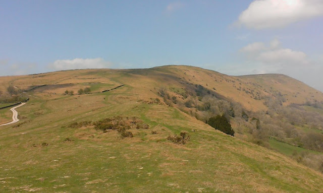
The Hatterall ridge looking north from its southern-most point at Trewyn 'hill fort'.

The Hatterall, or versions of it, is a long-standing name used in times past for the eastern uplands of the Black Mountains, now used more particularly for the heights between the Vale of Ewyas and the valleys of the Monnow and Olchon; a ridge that carries both the England-Wales border and the Offa's Dyke National Trail. The Welsh names of hills and mountains typically have fairly prosaic meanings (though rendered more exotic to English ears) - 'big hill', 'top of the hill', 'great mountain' and such-like. In contrast, Hatterall has an interesting and varied etymology as it has evolved from its (probable) lyrical origins to its puzzling Anglo-Welsh hybrid present. As the examples below demonstrate, there have been many variations in documents, books and maps as use by non-literate cultures, misunderstandings, mishearings and Anglicisation have morphed and moulded the words through the centuries.


A borderland: Offa's Dyke path above Llanthony, looking south.

At y Heu (probable original name, though undocumented - 'hill towards the sun' in Welsh)

 Hatiram (1137)

  Hatyre (12th century)

    Hateroll (1325)

      Haterhill (1566)

        Hatherall (1574)

           Hattrell (1612)

             Hatyrel, Hatterras (1905)

               Hateral, Hatterrall (20th century)

                  Hatterall Hill or The Hatterall (modern name - 'hill towards the sun hill'!)


The Black Darren land-slip in the Olchon Valley.


Above the Cwm-iau valley.

The steep eastern slopes of Hatterall above Oldcastle.

Stone wall alongside the Beer Path from Llanthony up to the Hatterall ridge.

A distant Llanthony Priory from the high boundary of Walter Savage Landor's park on the slopes of Hatterall.

Friday 10 February 2017

Deep topography practice – landscape walks as PhD fieldwork


Composite map of the landscape walk routes in the Llanthony Priory case study (Source: map drawn in ArcGIS using ArcGIS World Imagery basemap).

A note here on the experiential landscape walks that I am undertaking across the three case study areas on which my PhD research is focussed, a core element in an interdisciplinary approach: blending the solid of landscape history with the drift of landscape perception. 

One key purpose is to bridge the traditional fieldwork focus on macro-level reconnaissance across relatively large areas on the one hand and smaller-scale targeting of specific sites and features through survey, field walking, test pitting and so on on the other. The walks aim to fulfil a complementary and linking middle ground that also provides additional evidence and value. More fundamentally, actually walking and moving through the landscape on foot, experiencing and investigating on the ground, helps to provide a more nuanced, fleshed-out and three-dimensional feeling to supplement important but formulaic desk-based study focused on academic reading and ‘birds eye’ views from aerial photographs, satellite imagery and maps and so forth. This is deep topography in practice: a deepening understanding of landscape history allied to a deeper perceptual viewpoint. Getting to know a landscape, its biography through walking.


The old roadway to Llanthony Priory from Longtown and its Herefordshire estates, now disused; investigated on the Llanthony to Longtown landscape walk.

I have appropriated 'deep topography' here from Nick Papadimitriou's description of his 'conscious walking' through the fringes and suburbs of North London, most expansively articulated in his book Scarp: In Search of London's Outer Limits (2013). This terminology could also be used to describe the work of outlier geographers, largely operating outside of the academic arena, such as Patrick Keiller (The View from the Train: Cities and Other Landscapes, 2013), Tim Robinson (Stones of Aran: Pilgrimage, 1990) and Will Self (Psychogeography, 2007). All exponents of a more nuanced counterpart to the now perhaps over-cooked concept of 'psycho-geography', less shackled to its conceptual and urban prescriptions. Self has described deep topography as ‘minutely detailed, multi-level examinations of select locales that impact upon the writer’s own microscopic inner-eye’, combining ecology, history, poetry and sociology; or in Nick Papadimitrou’s own terms ‘an acknowledgement of the magnitude of response to landscape.’ A mention here of another related concept, phenomenology, which this research also aims to integrate. A phenomenological approach views the environment as more than just a passive backdrop or external object of the spectator’s gaze; providing a challenge to more traditional ideas of landscape as simply a way of seeing the world or a repository of empirical material data. Ideas taken forward most notably in relation to landscape by archaeologist Christopher Tilley (A Phenomenology of Landscape: Places, Paths and Monuments, 1994) and anthropologist and cultural geographer Tim Ingold (Imagining Landscapes, Past, Present and Future, with Monica Janowski, 2012).

Although psycho-geographical texts and practice have attracted academic interest in recent years, this has tended to be within the confines of cultural geography and literary studies and focused on the urban experience, whilst the extensive archaeological practice of phenomenology has largely been limited to the study of prehistoric landscapes. As Papadimitriou’s ventures into deep topography throughout the Middlesex-Hertfordshire boundary lands and W.G. Sebald’s long existential walk along the East Anglian coast (The Rings of Saturn, 1995) demonstrate, any landscape can in principle be opened up to what Iain Sinclair has described as: ‘psycho-geography lite. It was a long way from the Situationists but it suited the English sentiment about walking, deep-topography, historical scavenging.’ This is the context for my tramps through the countryside of the southern Welsh Marches, looking for the liminal topographical ghosts of monasticism.


An old wall in the woods above the Angidy Brook, possibly a boundary of the 'lost' Tintern abbey grange of Secular Firmary; investigated on the Porthcasseg landscape walk.

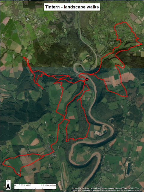
A series of walks is being undertaken in each case study area focussed on particular themes, features and objectives identified through initial desk-based analysis, but with scope to venture ‘off-piste’ when in the field (composite maps of the walks taken so far in the Llanthony and Tintern case studies are provided here). Through a mix of observation, photography and note-taking places that can be easily overlooked, neglected or invisible to the casual eye are investigated and recorded. The footpaths, lanes and off-the-beaten-track routes followed form a sort of outdoor laboratory for the crystallizing of thoughts, ideas and connections, found evidence of the medieval and historic landscape and a wider appreciation of the geography of, and feeling for, the landscape as it is passed through. A mental map taken back to enrich work at lap-top and desk. 


Composite map of the landscape walk routes in the Tintern Abbey case study (Source: map drawn in ArcGIS using ArcGIS World Imagery basemap).

The output from the walks is a set of commentaries and photographs of the landscapes encountered both from a physical and perceptual perspective, with an accompanying map of the route. As well as informing the main narrative these notes, which will be presented in a standard format as an online resource alongside the main Thesis (see example screenshot extract below), are intended as a more in-depth supplement to the main text. The discussion section of the Thesis will also critically evaluate what worked well and less well in integrating this approach with more conventional landscape archaeology and history research tools. 


Extract from Cwmyoy South landscape walk notes.
Finally, back to Nick Papadimitriou. In an interview on the subject of his deep topography practice at the London Short Film Festival, he outlined six tips for deep topography walking. The approach adopted for my research does not necessarily stick to all of these principles and aims to demonstrate a more expansive fusion of such metaphysical exploration with other approaches, but they provide a useful starting point and stimulus: 
  • Go walking. Stay away from bright lights. 
  • Explore second hand bookshops. Buy books on topography – on areas, regions, counties. Study them. Then walk around and see whether you can make sense of the present landscape in relation to the past. This way you’ll get more tension and depth in your engagement with the landscape. 
  • Go out on your own without any maps and without a digital camera. Digital cameras are the death of the imagination. 
  • Go in any direction that suits you. Go in unfamiliar directions. Go in familiar directions and try and see things in a new way. 
  • Develop a sense of contours. They tell you a lot about the tensions and releases of the landscape and the way the ancillary aspects if the landscape (such as sewage and drainage systems) are organised. It will build up your sense of place. 
  • Develop a poetry out of the commonplace. The two aren’t opposites. The inexplicable and the obvious reside alongside each other. 
Nick expands on his approach in John Roger's documentary The London Perambulator: Afoot in London's Edgelands (2009):